LAVA FLOW HAZARD ZONE MAPS |
 |
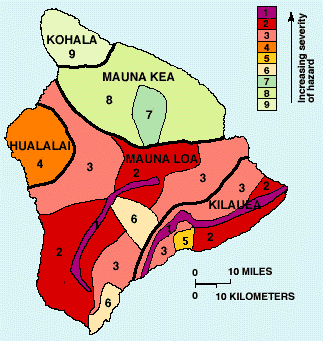
Maps showing volcanic hazard zones on the island of Hawaii were first prepared in 1974 by Donal Mullineaux and Donald Peterson of the U.S. Geological Survey and were revised in 1987. The current map divides the island into zones that are ranked from 1 through 9 based on the probability of coverage by lava flows. Other direct hazards from eruptions, such as tephra fallout and ground cracking and settling, are not specifically considered on this map; however, these hazards also tend to be greatest in the areas of highest hazard from lava flows.
|
| The island of Hawaii is divided into zones according to the degree of hazard from lava flows. Zone 1 is the area of the greatest hazard, Zone 9 of the least. To read more about a particular volcano or zone, click on the area of interest in the map or on the text links below. |
[ Kilauea || Mauna Kea-Kohala || Hualalai || Mauna Loa ]
Hazard zones from lava flows are based chiefly on the location and frequency of both historic and prehistoric eruptions. “Historic eruptions” include those for which there are written records, beginning in the early 1800’s, and those that are known from the oral traditions of the Hawaiians. Our knowledge of prehistoric eruptions is based on geologic mapping and dating of the old flows of each volcano. The hazard zones also take into account the larger topographic features of the volcanoes that will affect the distribution of lava flows. Finally, any hazard assessment is based on the assumption that future eruptions will be similar to those in the past.
HAZARD ZONES FOR LAVA FLOWS |
|||
|---|---|---|---|
|
Zone |
Percentage of area covered by lava since 1800 |
Percentage of area covered by lava in last 750 years |
Explanation |
|
1 |
greater than 25 |
greater than 65 |
Includes the summits and rift zones of Kilauea and Mauna Loa where vents have been repeatedly active in historic time. |
|
2 |
15-25 |
25-75 |
Areas adjacent to and downslope of active rift zones. |
|
3 |
1-5 |
15-75 |
Areas gradationally less hazardous than Zone 2 because of greater distance from recently active vents and/or because the topography makes it less likely that flows will cover these areas. |
|
4 |
about 5 |
less than 15 |
Includes all of Hualalai, where the frequency of eruptions is lower than on Kilauea and Mauna Loa. Flows typically cover large areas. |
|
5 |
none |
about 50 |
Areas currently protected from lava flows by the topography of the volcano. |
|
6 |
none |
very little |
Same as Zone 5. |
|
7 |
none |
none |
20 percent of this area covered by lava in the last 10,000 yrs. |
|
8 |
none |
none |
Only a few percent of this area covered in the past 10,000 yrs. |
|
9 |
none |
none |
No eruption in this area for the past 60,000 yrs. |
Hazard zone boundaries are approximate. The change in the degree of hazard from one zone to the next is generally gradual rather than abrupt, and the change can occur over the distance of a mile or more. Within a single hazard zone, the severity of hazard may vary on a scale too fine to map. These variations may be the result of gradual changes that extend across the entire zone. For example, the hazard posed by lava flows decreases gradually as the distance from vents increases.
There may be abrupt changes, however, in the relative hazard because of the local topography. For example, the hills behind Ninole stand high above the adjacent slopes of Mauna Loa and consequently are at a much lower risk from lava flows than the surrounding area, even though the entire area is included in a single zone. To determine the hazard differences within a single zone, more detailed studies are required.
This page contains content copied from the USGS website.